The centre of controversy: Where is Canada’s middle?
The people of Baker Lake, Nunavut, are proud of their coordinates: 64 degrees, 18 minutes, 41 seconds N and 96 degrees, 4 minutes, 8 seconds W. In 1951, someone bushwhacked through the forest on the periphery of town and hammered a sign into the dirt proclaiming, “Geographical centre of Canada.” Billboards at the airport and town hall, as well as the mantra on the town’s pamphlets and website, will not let anyone forget it. “We’re the centre, the core,” says Denis Zettler, the senior administrative officer of the 1,728-person town. “We’ve got the documentation. We all know it. Everybody knows it.”
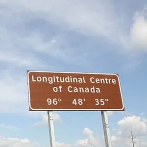
Well, not everybody. Around 1,600 km south, the rural municipality of Taché, Man., has lately started bragging about its centrality, as well. While Baker Lake claims to be the centre both in longitude and latitude, Taché celebrates longitude alone. Positioned just southeast of Winnipeg, at 96 degrees, 48 minutes, 35 seconds W, locals recently announced visions for a $5-million project: the Centre of Canada Park.
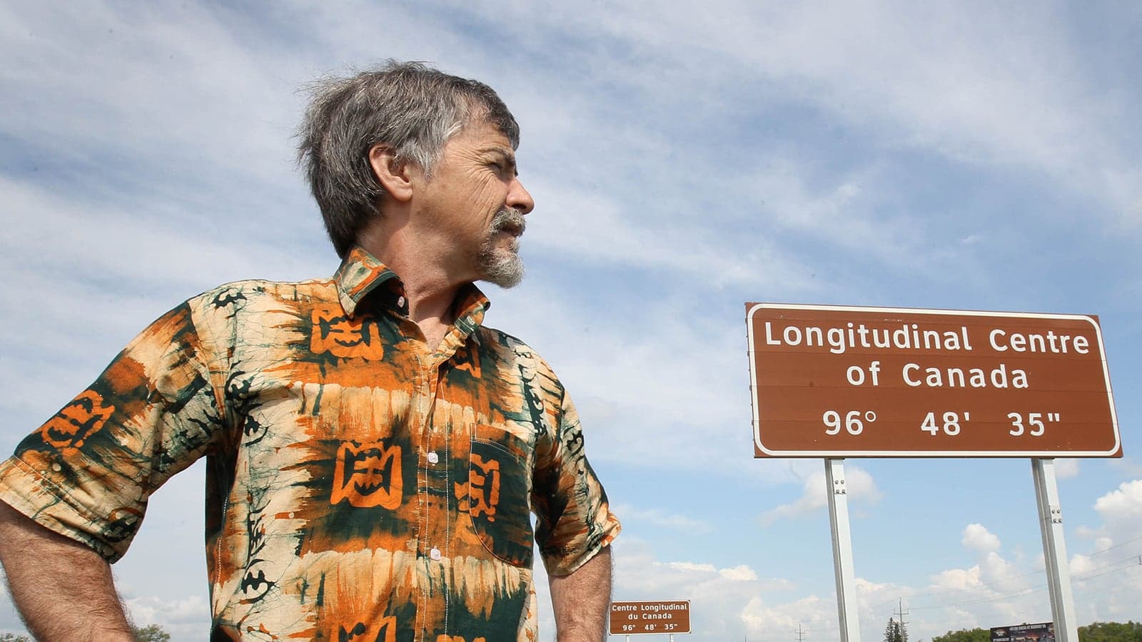
“Obviously, it’s significant,” says Bill Heather, a Taché councillor. He and his fellow project leaders plan to develop a eight-hectare plot, which could triple in size. Space is not the problem: The plot is currently a grain field, bought by the municipality in 2008 for about $70,000. But the plan is to glorify the site as a “spectacular monument,” a “tourist destination” and a “national meeting place.” Ambitions include venues for concerts and weddings, a commercial complex, sculptures of the four winds, WiFi hot spots, playgrounds, and an archway called the Great East-West Portal. The team hopes to secure $150,000 from the federal government, along with corporate sponsorships and $200 donations from people who want their names engraved on bricks.
“We’re ready to make things happen,” says Heather. “Travellers should get to have a full experience while they enjoy this symbolic place.” Planners hope to finish the park by 2017 for Canada’s 150th birthday, and to plant an underground time capsule to open 50 years later. In its fundraising materials, the team promises the park will “symbolically bridge eastern and western Canada,” “inspire future generations” and attract international tourists “to ponder the breadth of our country and the meaning of being Canadian.”
For now, the only thing marking Taché as the middle of the road is a bland federal highway sign. Nevertheless, more than 10,000 vehicles drive past it each day, and travellers tend to stop to pose for pictures. Heather admits the site in Nunavut has the added significance of latitude. “But I wouldn’t make a trip of it,” he says.
Related Posts
The only acceptable response to Vladimir Putin

The Coutts blockade and controlling the narrative
Back in Baker Lake, locals demand that x and y mark the spot. “I’d like to know why Manitoba would think it comes anywhere close to Baker Lake as a significant centre,” says Zettler. “The people of Baker Lake would be very, very upset to hear about that.”
Zettler’s neighbours talk fondly of their centre-of-Canada site: a riverside clearing with a three-metre-high inukshuk towering next to the sign. Baker Lake gets about 100 tourists each year, mainly canoers on the Kazan River, who stop for the only groceries they’ll get in four days. The river is frozen to boaters for seven months of the year, and milk-run flights from Winnipeg can take eight hours or more and cost around $3,000 each way. Local fishermen and caribou hunters use the trail leading to the site, which doesn’t attract as many visitors as intended.
“We need to get a whack of pamphlets out,” says Trevor Attungala, the economic development officer for the town. Attungula had never heard of the Centre of Canada Park in Manitoba. “It’s pretty funny that they’re claiming to be the centre,” he says. “I don’t want to put them down, but they’ve got to get back to geography class.”
Meanwhile, Baker Lake has plans of its own. A development committee hopes to turn the site into a municipal park with a monument and pavilion, adorned with flowerbeds. They also hope to promote the town in airports in other territories and to keep improving their new website, always spreading the greeting, “Welcome to Baker Lake. The Centre of Canada.”
Even this, however, might be false advertising. Christopher Storie, president of the Canadian Cartographic Association, uses Atlas of Canada coordinates to find the extreme tips of the country, enters them in an algorithm that creates an elipse, then finds the cross point of its axes. He determines the centre of the country is actually about 275 km southwest of Baker Lake, on the barren shores of a water body called Yathkyed Lake. No cabins, no campsites and certainly no sign. The only interest in the lake appears to be from a mining company that is prospecting in the area. (Indeed, the true centre of Canada could be a pot of gold.)
“I’m not sure how they came up with Baker Lake as the centre,” says Storie. “I guess it was good PR.”
Although it’s not known who determined the site in 1951, Storie says they may also have come to different conclusions because they used hand drawings and aerial photography to find Canada’s tips, not satellite imagery. However, he says the shape of Canada makes it difficult to find the centre, even today. “We’re not a square or a circle. We’re huge, is what we are.”
Still other cartographers calculate different coordinates. Shawn Morgan, a geomatics professor at Fleming College, found the centre to be about 400 km southwest of Baker Lake, on the shore of another barren lake. Although he started with the same coordinates as Storie, he used a different program, this one generating a scatter plot and finding the mean point.
Between cartographers and communities, equal debate arises regarding the centre of North America. While the United States Geological Survey states the centre has not been established, the town of Rugby, N.D., has a 4½-metre monument marking the spot. “Geographic centres are never clear,” says Storie. “It’s a good thing we’re not trying to balance the world on a point.”
Still, Baker Lakers take any questioning of coordinates to heart. “People shouldn’t think they’re at the centre if they’re anywhere else,” says Zettler. “There can only be one centre, and that’s us.”
Provincial centres from above
British Columbia: 54° 45’ 16" N 124° 45’ 58" W
Closest community: Sunnyside/Tachie (12km N)
Alberta: 55° 10’ 11" N 114° 30’ 39" W
Closest community: Slave Lake/Sawridge (20km SE)
Saskatchewan: 54° 25’ 05" N 105° 53’ 22" W
Closest community: Waskesiu Lake (6km W)
‘It’s nice to know you’re the centre. It’s a landmark, but it’s not usually advertised or written about. It should be known by everybody.’ —Rita Winacott, Waskesiu Lake, Sask.
Manitoba: 54° 55’ 46" N97° 25’ 56" W
Closest community: Cross Lake (40km NE)
‘I had no idea. That’s enlightening’ —Bob Johnson, Cross Lake, Man.
Ontario: 50° 26’ 43" N 86° 02’ 49" W
Closest community: Margo Lake (50km NE)
Quebec: 53° 23’ 34" N 71° 46’ 53" W
Closest community: Mont-Wright (290km W)
Newfoundland and Labrador: 52° 53’ 23" N 60° 30’ 39" W
Closest community: Happy Valley Goose Bay (50km S)
‘It says “the heart of Labrador” on our sign. Everything’s here. You have stores and roads and ways out. It doesn’t feel like you’re stranded at all.’ —Olivia Paul, Happy Valley-GooseBay, Labrador
New Brunswick: 46° 37’ 01" N 66° 22’ 42" W
Closest community: Priceville (14km NW)
Nova Scotia: 45° 08’ 45" N 63° 19’ 54" W
Closest community: Stewiacke (3km NE)
Prince Edward Island: 46° 23’ 25" N 63° 14’ 45" W
Closest community: Oyster Bed Bridge (2km NW)
‘We can go for a drive and we can go east, or we can go west. We can go visiting at either end in an afternoon.’
—Dot Campbell, Oyster Bed Bridge, P.E.I.
Yukon: 63° 37’ 52" N 135° 30’ 40" W
Closest community: Mayo (20km E)
Northwest Territories: 66° 22’ 49" N 119° 00’ 01" W
Closest community: Kugluktuk(NU) (250km SW)
Nunavut: 71° 01’ 10" N 88° 52’ 36 "W
Closest community: Taloyoak (260km NE)
Sources: Meghan Miller, Shawn Morgan, Christopher Storie
Related Posts

My love for the giant that is Ukraine

A glaring omission from Trudeau’s letters to his ministers: hunger
Why sanctions over the Ukraine invasion won’t stop Putin

The Age of Wildfires
Get the Best of Maclean’s straight to your inbox.
Sign up for news, commentary and analysis. Join 60,000+ Canadian readers.