
Inside the search for Flight MH370
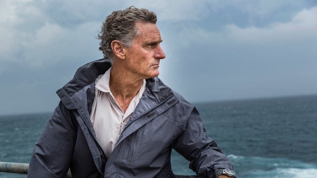
Peter Barr has seen a lot of ocean in his 58 years. He’s worked as a hydrographer for oil and gas firms in the North Sea, off Newfoundland’s Grand Banks and, more recently, along the western coast of Africa. But the 60,000-sq.-km swath of southern Indian Ocean he helped search for Malaysia Airlines Flight MH370, missing since last March, stands apart—not so much for what’s out there, but for what isn’t.
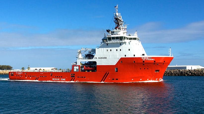
Barr didn’t see any other ships during his six-week stint aboard GO Phoenix, one of four official search vessels that have pinged the seabed with sonar over the past six months. Nor did he spot so much as a single dirty water bottle bobbing in the near-freezing swells, a rarity in today’s plastic-choked oceans. And, it goes without saying (as this magazine went to print), there’s been no sign so far of the missing Boeing 777, or its 239 passengers and crew.
“It’s very remote and it’s very rough,” says Barr, an Australian who spent nine years living in Canada and still regularly visits his wife’s family in Cape Breton, N.S.—a province that, incidentally, boasts a total land area about 5,000 sq. km smaller than the current “priority” search zone for MH370. The long, gently curving patch of ocean is in an area almost completely devoid of commercial shipping traffic and, until now, featured an unmapped sea floor more mysterious than the surface of the moon. What it lacks in evidence of mankind’s reach, however, it more than makes up for in seabirds, including wandering albatross and storm petrels, Barr says.
MH370 first went missing on March 8 last year, about 40 minutes into a routine flight from Kuala Lumpur to Beijing. Initially, it was believed the plane went down in the South China Sea. It was later determined that military radar had tracked the plane back across the Malay Peninsula, and that it had continued flying for another six hours after that, based on periodic signals sent to a nearby satellite, until it presumably ran out of fuel somewhere far off the western coast of Australia.
Searching for the downed jet in the Indian Ocean is slow, painstaking work. The swells are big, the water deep, and there’s nowhere to hide when cyclonic storms roll through the region, as they did last month. If someone gets hurt or sick, he or she faces a six-day sail back to the nearest port in Perth, about 1,800 km away.
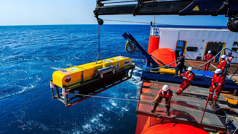
The challenges down below are equally daunting. The section of sea floor where MH370, or parts of it, is believed to have come to rest is as much as six kilometres from the surface. It’s a pitch-black world composed of plummeting valleys and soaring seamounts. And while GO Phoenix is armed with a sophisticated towed sonar array capable of generating high-resolution images of the bottom, Barr says keeping the “towfish” humming at the end of its seven-kilometre cable is difficult due to the roughly 8,500 lb. per square inch of pressure exerted on the equipment at that depth. “Huge pressure presents huge problems with getting [electrical] power down there,” says Barr, “and you need high power for the propagation of the sonar signals.”
Finding the wreckage, and the clues it contains, is key to solving what’s become one of the biggest mysteries in modern aviation. Officially, the incident has been ruled an accident, so Malaysia Airlines can begin the process of compensating grieving families, but investigators have said the plane was deliberately steered off course—but by whom or for what purpose, nobody knows. Possibilities range from an on-board fire that incapacitated the crew to a suicidal plot hatched by the pilots.
But with nearly half the search zone having been scanned without locating a single floating seat cushion, what began as an earnest, multinational rescue effort is already threatening to end in political bickering and spiralling costs. Although Australia has said it is committed to completing the current phase of the search by May, and has so far set aside about $85 million to pay for it, Deputy Prime Minister Warren Truss this week suggested the hunt will be called off soon if nothing is found. The total area where MH370 could have theoretically gone down is about 1.1 million sq. km, which may be too large to be feasibly searched, he said.
The nightmare scenario is that a ship may have already sailed over the debris field but failed to detect it. Experts say not all sonar is created equal, and there’s relatively little agreement within the deep-sea search industry about what constitutes best-in-class equipment anyway. All of which makes the work now being done aboard the GO Phoenix and other ships more crucial than ever. If they fail to find MH370 soon, in other words, it may forever be lost to the deep.
Aboard GO Phoenix, 35 crew members work in two shifts around the clock. One starts at noon and finishes at midnight, the other works from midnight to noon. When not manning the sonar and tending to the ship’s various needs, the crew have access to a gym and the Internet, although the connection can be spotty. Occasionally, a poker game breaks out. “The Ukrainian, Croatian and Indonesian chefs and stewards have been making excellent meals and doing great work in stretching the livelihood of fruits and veggies,” says Jay Larsen, an American sonar engineer currently on board.
Working in tandem with three other ships, GO Phoenix travels up and down the narrow search zone, scanning long, 2.4-km-wide slices of the sea floor in a careful, overlapping search technique referred to as “mowing the lawn.” The 91-m GO Phoenix is normally used to haul anchors to offshore oil rigs, but is ideal for this type of search mission because its giant rear winch can spool out the kilometres of heavy cable needed to tow the side-scan sonar array, which weighs about as much as a pick-up truck. Far beneath the waves, the towfish flies about 100 m above the sea floor, sending out sound waves diagonally that bounce off the bottom and paint acoustic images of features on either side. The data, terabytes of it, is whisked back up to computers on the ship, where it’s analyzed for signs of man-made objects—in this case, a missing airplane.
“If there’s something happening or the data is looking interesting, or has changed and is something that hasn’t been seen before, then we were up looking at it,” Barr says, adding that the work was far more interesting than his usual diet of oil and gas survey jobs. “There were some long days for me. But most of the guys were in shifts, so they get into a very strict routine. You just try to maintain that and hope it doesn’t get too rough.”
Rough is a relative term in this part of the world. The search zone extends down into a region that seafarers call the “roaring forties” because of the strong westerly winds that howl up from Antarctica with no land masses in their way to dissipate their energy. Barr counts himself lucky to have only experienced “constant large swells” and to have been aboard the relatively large GO Phoenix, which is less prone to pitching and rolling. “You get used to it. You have to live with everything moving,” he says,“your food skidding across the table and that sort of thing.”
Others haven’t been so fortunate. Search operations were temporarily halted last month as tropical cyclone Eunice and ex-tropical cyclone Diamondra caused swells of up to 12 m. “We have encountered pretty severe weather here and there, and had to run from one cyclone,” Larsen says. “The biggest swell we’ve seen is about seven to eight metres, but the frequency”—the space between the swells— “was low enough that they weren’t breaking over the rails. Our vessel was just riding them, and they looked like small hills rolling around out here.” It’s sobering to consider this is summertime in the southern hemisphere. It will get far worse with the onset of winter, which is why Australian authorities hope to wrap up this phase of the search before then.
Hectic conditions at the surface also create problems underwater—and there’s more than enough down there already. Side-scan sonar works best when the towfish is pulled at a constant depth, allowing it to accurately gauge the relative height of terrain and any objects sitting on it. But that’s more difficult to do if the ship is pitching up and down with the waves. Software helps to compensate for the vertical motion, but images can nevertheless end up distorted—a problem when trying to spot debris as small as a few metres in length, and scattered over a kilometre or more.
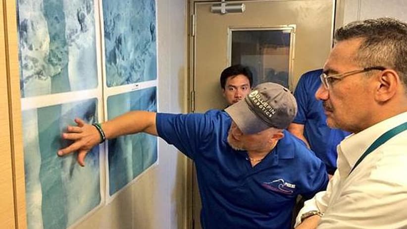
To make matters worse, the terrain at the bottom is unusually rugged. MH370 is believed to have gone down near a sub-sea feature called Broken Ridge, a long, mountainous geologic formation that once marked the margin of two separate plates of the Earth’s crust. Since the area has never been properly mapped, Australian authorities first commissioned a three-month bathymetric survey—essentially a lower-resolution sonar scan done from the surface—to prevent search teams from towing their pricey sonar equipment into an underwater cliff. The images revealed dramatic terrain composed of old volcanoes, 300-m-tall ridges and depressions up to 1,400 m deep—in other words, plenty of nooks and crannies that pieces of a broken-up jetliner could drift into after raining into the darkness from six kilometres above.
Aboard the GO Phoenix, Larsen is ultimately charged with scoping out all those crevices for signs of MH370. His tiny sonar company, Hydrospheric Solutions, is based in the unlikely ski town of Whitefish, Mont., and was brought aboard by Maryland’s Phoenix International Holdings, which, in turn, was hired by a Malaysian defence contractor. Unlike the other sonar arrays being used by the other three ships in the area, all operated by Dutch survey firm Fugro, Larsen’s ProSAS60 uses synthetic aperture technology to take photograph-like images of the sea bottom. It works by taking multiple pings of the same spot of sea floor as the towfish passes, then reassembling the data into a single image using complex software. Whereas traditional side-scan sonar tends to get fuzzy at the edges (think of how a flashlight pointed at the floor illuminates brightest directly underneath), the ProSAS60 maintains its resolution right across the image. That can be a huge plus when you’re stitching together hundreds of slices of the sea floor and don’t want anything—a few rows of seats, a broken piece of fuselage—to accidentally become obscured in the margins.
Larsen, who has been aboard GO Phoenix since September, with only a brief break over Christmas, describes the system as the “ultimate tool for deep, large-area searches in rough terrain,” and believes it will revolutionize the industry—particularly if it manages to find the missing plane. Larsen’s 20-year-old son, Kolter, joined him on GO Phoenix for several weeks while taking a semester off university. Though far younger than the rest of the crew, Larsen’s son boasts an intimate knowledge of the equipment, some of which he helped solder together on a Ping-Pong table in the family garage, according to an article in a local Montana newspaper. Yet, despite the luxury of having family present, Larsen still describes the mission as gruelling. “The longevity of this project can wear people down,” he says, adding that the search teams received Christmas cards from many of the victims’ families last December to help keep their spirits up. “But the thought that the airplane can roll across the screen at any given ping helps to keep us going.”

The hunt for MH370 was characterized by confusion and missteps from the moment the airplane vanished. Friends and family of the missing, the majority of them from China, were subjected to a macabre theatre of the absurd that played out daily at a Beijing hotel, where the airline had promised regular updates. One moment it was a search operation in the Gulf of Thailand. Next, the whole operation shifted hundreds of kilometres west into the Strait of Malacca after military radar detected that the plane made a near-180° turn and appeared to follow a series of checkpoints until it disappeared from radar about an hour later. Not long after, the world learned the plane had continued flying for several more hours, raising hopes the missing were still alive somehow, somewhere. Soon, the horrific cycle started all over again when authorities began searching for wreckage off the coast of Australia.
Theories about what happened ran the gamut from mid-air accident to a James Bond-like plot. They were fed by the 24-hour cable news frenzy on outlets like CNN, which even commandeered its own 777 flight simulator in Mississauga, Ont., to run through the various scenarios. If it were an accident, pundits wondered, why had the pilots not radioed for help? And why did the plane’s transponders—which broadcast the plane’s identity and position to air traffic control—as well as an on-board satellite communications system go silent before the plane made what appeared to be a controlled turn to head back toward Malaysia? Perhaps the pilots were struggling with an on-board emergency, such as a fire, and were desperately trying to find an airport to make an emergency landing? Or maybe someone on board with sophisticated knowledge of the 777 had deliberately tampered with the communication systems to make the plane “disappear?”
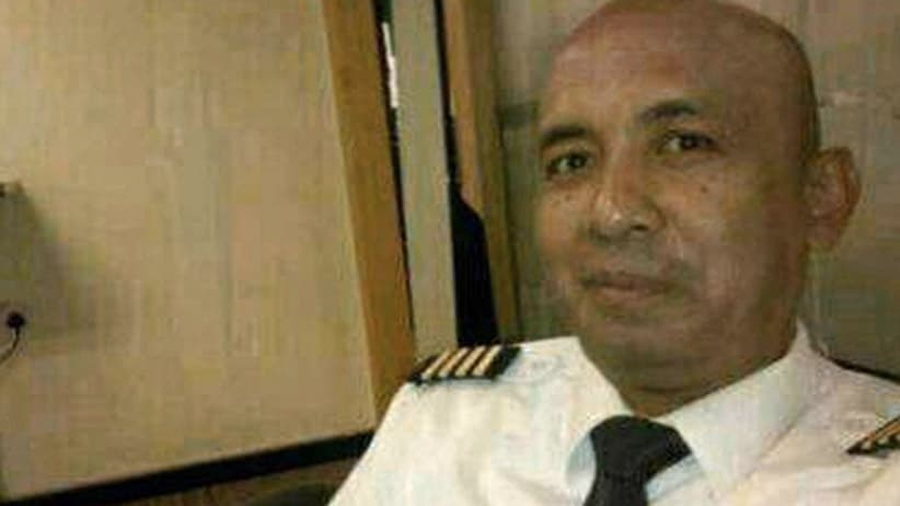
It wasn’t long before the investigation swung to focus on the two pilots. Detectives raided the home of Capt. Zaharie Ahmad Shah and found a homemade flight simulator, which apparently had been programmed with a scenario that involved a landing in a remote island in the far southern Indian Ocean, but was later erased. However, officials said there simply wasn’t enough evidence to suggest that either Zaharie or co-pilot Fariq Abdul Hamid was responsible, let alone come up with a possible motive. Online discussion boards also lit up with comments about a known “vulnerability” of the 777: an electronics bay that, if left unlocked, could be accessed from the passenger cabin. Other lines of inquiry, meanwhile, focused on containers of potentially flammable lithium-ion batteries for laptops and cellphones in the plane’s cargo hold.
Many believe there’s more to the story than investigators have let on. “This aircraft, in my opinion, was under control, probably until the very end,” Tim Clark, the CEO of Emirates, one of the world’s biggest airlines, said in an interview with a German aviation journalist in November. He expressed disbelief that authorities have so far failed to unearth a shred of conclusive evidence about MH370’s flight path after it fell off the radar in the Andaman Sea. After all, it should have still been in the airspace tracked by both Malaysia and Indonesia, assuming it turned south, but neither claims it saw anything out of the ordinary. “There hasn’t been one over-water incident in the history of civil aviation, apart from Amelia Earhart in 1939, that has not been at least five or 10 per cent trackable,” Clark said. “This has disappeared. So, for me, that raises a degree of suspicion, and I’m totally dissatisfied with what has been coming out of all of this.”
However, it’s also true that piecing together the final moments of MH370’s probable flight path—and, therefore, the most likely crash site—has required an inordinate amount of guesswork. The only reason investigators were able to surmise that MH370 ended up in the southern Indian Ocean, more than 10,000 km away from where it was originally headed, is because it executed several “handshakes” with an orbiting satellite owned by British firm Inmarsat. The partial communications—seven of them in total—were compared with information about the 777’s range, last-known position, and how much fuel was on board, to narrow MH370’s probable crash site to two long arcs on the globe: one stretching northwest into Central Asia and another southwest into the Indian Ocean. Even so, the total search area remained the same size as the continent of Australia.
The big break that determined the plane could be found along the southern arc was due to a fluke that resulted from lazy aerospace engineers and a thrifty satellite operator, according to Michael Exner, a pioneer in the U.S. mobile satellite communications industry. He says the engineers who designed the 777’s satellite transmission equipment took a shortcut by assuming the plane would communicate with a satellite in a geostationary orbit, meaning one that stays in the same spot directly above the Earth’s equator. But not all do. The Inmarsat satellite over the Indian Ocean, for one, was old and running out of hydrazine, the fuel used to power the thrusters that maintain its precise position. In a bid to extend its lifespan, the satellite had been allowed to wander a few degrees from its orbital plane. Those two decisions, made by different companies for different reasons, made it possible to track the MH370’s direction, thanks to something known as the burst-frequency offset, or BFO, which is the difference between the radio frequency the plane’s communications were expected to arrive on, and the ones actually recorded. “We’re so damn lucky that those engineers didn’t use a perfect model,” says Exner, who is a member of an online group of about 18 independent experts that includes a New Zealand-based NASA space scientist, a U.K. pilot and a Chicago patent lawyer. “If they had, we wouldn’t have a clue. But because they took a shortcut, we’ve got this little fuzzy signal. But it’s a signal nevertheless, and it’s telling you which direction the plane was heading.”
The calculations done by Exner’s group, which met on an online discussion forum, suggested as far back as June where search teams should focus their energy. Instead, the flotilla of ships and airplanes that descended on the Indian Ocean in the weeks immediately following MH370’s disappearance were distracted by debris spotted by satellites, and acoustic signals believed to have originated from the plane’s black-box recorders. All proved to be false leads. Based on a complex statistical analysis of the satellite transmissions, the Australian Transport Safety Bureau, or ATSB, settled on a search area farther north along the arc. But Exner says it ignored a few common-sense assumptions about how a Boeing 777 would likely be flown. The two views have since been reconciled, placing the official “priority” search zone in roughly the same spot that Exner and his ragtag group originally recommended. Daniel O’Malley, a spokesperson for the ATSB, didn’t dispute the idea that the so-called “Independent Group” may have helped to guide the official investigation. “The ATSB receives many theories from members of the public and various independent experts and we take each seriously, including the Independent Group,” he said in an emailed statement.
Of course, because nothing to do with MH370 is ever simple, one of the Independent Group’s members, science writer and CNN aviation analyst Jeff Wise, recently wrote an article for New York magazine that laid out an alternative scenario, where MH370 might have flown north and landed at a remote runway in Kazakhstan. He called it his pet theory on MH370 and claims it fits the available data as well as any other. And what of those satellite signals and BFOs? Wise says someone—perhaps the Russians—could have tampered with them deliberately to throw investigators off their trail.

Out on the water, there’s no time for entertaining the increasingly far-fetched theories about MH370’s fate. All attention is focused on making sure GO Phoenix and the three other Fugro ships aren’t busy churning out a bunch of false negatives. “This is the fundamental part of business,” says Rob McCallum, a partner at Seattle-based Williamson & Associates, a deep-sea search firm that was outbid by Fugro on the current $50-million search contract. “The most important thing we can do is tell you where it’s definitely not. You have to be able to say, with your hand on your heart, ‘We’ve searched this area and what you’re looking for isn’t there.’ ”
However, McCallum isn’t convinced that’s what’s happened off the coast of Australia. He says Fugro, the oil and gas survey firm that landed the biggest search contract, lacks experience in looking for man-made objects in the deep ocean and is therefore at risk of missing subtle clues. “The company that got the job has never done this sort of work before,” McCallum says, adding that Fugro’s ships are also too small to handle the unforgiving seas in the search area, leading to excessive downtime.
There’s no question Fugro got off to a rocky start. It won the current search contract last August, but didn’t start operations until late October, more than a month behind schedule. A second vessel was delayed even longer, thanks to problems acquiring and installing the necessary sonar systems, according to a report in the Wall Street Journal. Fugro did not respond to requests seeking comment. The ATSB, for its part, says Fugro is delivering what’s required in its contract. “We and our expert advisers are satisfied with the quality of the search data that continues to be produced,” O’Malley said in a statement.
It’s also fair to say, however, that just about everyone in the deep-sea search business has an opinion on the best way to find an airplane lost in the deep. Some believe the future is in high-resolution synthetic aperture systems such as the ProSAS60. Others, like McCallum, advocate an approach that sacrifices ultra-high-resolution images for broader scans that cover more of the sea floor in each pass. There’s a further debate over whether it’s better to use towed systems, which are cumbersome, or nimble underwater drones like the one on Fugro Supporter that must be hauled up and recharged periodically.
In the end, the best sonar in the world won’t find anything unless it’s pointed in the right spot. That, more than anything, was the lesson learned from the search for Air France Flight 447, which went missing over the Atlantic in 2009 while flying to Paris from Rio de Janeiro. It took two years for search teams to find the remains of the Airbus A330 and its 228 passengers, despite having far more precise data about the plane’s last known position. They also discovered floating debris from Flight 447 immediately following the disaster, including bodies and part of a kitchen galley with in-flight meals still locked in it. In contrast, no debris from MH370 has ever been found—anywhere. That could be because it took weeks for the first ships to arrive in the southern Indian Ocean, giving the debris time to be dispersed by complex ocean currents. Recent drift modelling done by Australian authorities suggested wreckage could have been carried as far north as Indonesia after about five months. But Charitha Pattiaratchi, an oceanography professor at the University of Western Australia, says the finding conflicts with his models. “There is a very strong current called the south-equatorial current flowing east to west,” he says. It’s also possible MH370 could have gone down in one piece, if it landed on the water. Or, perhaps, it’s not even there at all.
Back aboard GO Phoenix, the hunt continues—for now. But Barr, at home in Sydney, Australia, is already preparing for his next job. He’s reluctant to answer the ultimate question: Will MH370 be found? It’s a touchy political subject, and everyone involved is under orders not to publicly handicap the chances. Privately, however, there’s a sense of optimism. The mathematical calculations about MH370’s likely crash site are reasonable, based on the limited data, and the sonar being used to comb the sea floor is capable, if used properly. But everyone involved also knows the sea is an unimaginably vast place full of dark secrets. After all, it took nearly 75 years to locate the wreck of the Titanic, which, unlike MH370, boasted hundreds of survivors.
After a brief pause, Barr finally threads the needle by recalling a conversation he had with his father-in-law in Cape Breton several months before he officially joined the search effort. The 92-year-old man wanted to know whether anyone would ever find that missing airplane. “I said: ‘I don’t know.’ ”
Related Posts

My devastating, inspiring trip to provide flood relief in Pakistan

‘Anybody want to drive this ambulance to Ukraine?’

“It wasn’t long before we were flooded with cholera patients”

Nothing prepared me for what I saw in Ukraine
Get the Best of Maclean’s straight to your inbox.
Sign up for news, commentary and analysis. Join 60,000+ Canadian readers.