Day 10 on the Trans-Canada, Borden, PEI
Trans-Canada distance: 1,317 km
Finding my way through PEI
Share
Trans-Canada distance: 1,317 km
Actual distance driven: 2,531 km
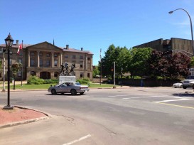
THEN: The Trans-Canada Highway used to come right through the middle of town in Charlottetown, along Grafton Street and up University Avenue. This was common practice across the country in 1962, because merchants wanted the inevitable traffic from tourists.
In Montreal, for example, the Trans-Canada Highway was officially placed right on St. Catherine Street downtown. But the merchants also got the inevitable truck traffic that comes with hauling goods around the country, and there are now bypasses to redirect traffic around commercial centres.
The Charlottetown bypass did not begin construction until the early 1980s, but today it loops around the island’s capital city. Some 200 trucks use it on average each day, staying well clear of the centre of town.
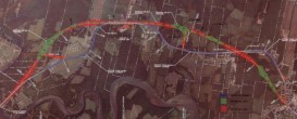
NOW: At the risk of over-alliteration, Prince Edward Island is an impossibly pretty, postcard-perfect province, and the Trans-Canada Highway dips and winds its way directly through several communities on its way between the bridge and the ferry. This may be pleasant on the two-lane portions, but it’s not efficient – and it’s dangerous. More accidents occur along the 6.1 km stretch near New Haven than anywhere else, and so as I wrote in yesterday’s blog, the province is widening and straightening that portion of road. Thirty-five properties will no longer have their driveways opening directly onto the TCH.
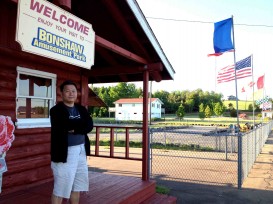
But not everyone is happy about this. “It doesn’t make any sense,” says Miller Choi, who owns the Bonshaw amusement park. There’s a small go-kart track on the 10 acres of land, as well as a pool for bumper boats and a mini-golf course, and it fronts directly onto the Trans-Canada. When the new road goes through on the other side of the trees behind, the amusement park will be cut off completely by the forest and drivers won’t see that it exists.
This was the first go-kart track in PEI and has been there for 42 years, says Choi. He doesn’t understand why the road is being directed behind his property and not in front of it, where it would continue to remove the sharp curve at the top of his hill.
“I bought this place (in 2005) for its exposure onto the highway,” he says. “In the summer, we get more than a hundred visitors a day, but we’ll lose that. It will all be terribly worse, but the government doesn’t care.”
Choi wants the government to compensate him for lost business, or buy his property at a fair current price, but he’s heard nothing from enquiries he’s made. And he’s not the only person who’s affected by the new routing.
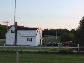
“I really don’t want to talk about it – everything’s in negotiations,” says the man who comes to the door of the white house on the other side of the hill. The house was built in 1862, and the new road will go right through its living room. He says he’s lived there for 47 years, but he doesn’t know where he’ll move to when his home is demolished for the road. As for protesting, he says he has no choice – when the government wants to do something, they just do it.
He does acknowledge, though, that the current stretch of road is dangerous. “There’s at least two, three, four times a year that people come knocking on my door and say they’ve put a car in the ditch,” he says.
Alex Calder is also losing part of his property’s lawn, but he’s circumspect about the situation.
“I can see the positives in it,” he says, pointing out how the new route will flatten the hill and remove two sharp S-curves. “Water drains down the road here and then freezes on the curve, where it’s in shadow, and cars, trucks hit the glare ice and that’s it for them. It’ll be a lot safer when it’s done, and that’s what’s important, isn’t it?”
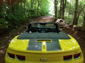
SOMETHING INTERESTING: No, this isn’t just a beauty shot of the Camaro convertible (though it does look pretty good). It’s a photo that illustrates what happens when you rely on a GPS mapping program to find your way around.
If everything’s bigger in Texas, then everything is smaller on Prince Edward Island. That extends right down to its country lanes, including this one, Peters Road, which started out as a regular two-laner and then, well, petered down to this.
Earlier, I’d stopped in to visit the office of the Canadian Automobile Association in Charlottetown and the helpful staff had offered to give me directions and a TripTik to get to Green Gables country, but I turned them down because I’m a guy and guys don’t ask for directions. Should’ve listened… They say it’s fun to get lost and it can be, but I was worried for the wide tires on the rocks in the mud, not to mention the low-slung chassis.
All turned out OK, but next time I’m on Peters Road, it’ll be with a dirt bike.