Satellite images show smoke from the B.C. fires hanging over Vancouver
(Post updated with new satellite image from Aug. 8) The smoke from multiple wildfires in B.C. has created hazardous breathing conditions across the province. In Kamloops, air quality is the worst in recorded history. A heat wave in the Lower Mainland coupled with the smoke has lead to a spike in 911 calls about breathing problems….
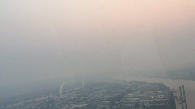
Smoke and haze hang over the Lower Mainland. (Darren Grieve, NEWS 1130 Photo)
Share
(Post updated with new satellite image from Aug. 8)
The smoke from multiple wildfires in B.C. has created hazardous breathing conditions across the province. In Kamloops, air quality is the worst in recorded history. A heat wave in the Lower Mainland coupled with the smoke has lead to a spike in 911 calls about breathing problems. Meanwhile the mountains on Vancouver’s north shore have vanished in the smokey haze.
This GIF, using satellite images taken by NASA taken between July 30 and August 8, shows the smoke from the fires spreading across the Lower Mainland and Vancouver Island.
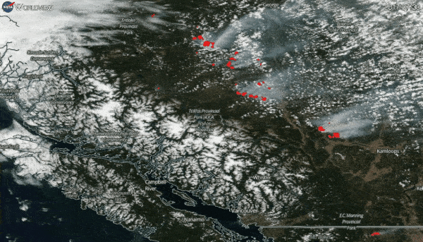
In the satellite images above, the red spots represent active fires and thermal anomalies. A provincial state of emergency has been extended until August 18, as more than 120 fires continue to burn across the province, and 25 communities are under evacuation orders.
MORE ABOUT B.C. WILDFIRES:
- Wildfire evacuation alerts lifted for 100 Mile House, B.C.
- Some B.C. wildfire evacuation orders lifted as Ottawa announces more funding
- Terror, agony and a new beginning in fire-scarred B.C.
- B.C. fires stir memories of Fort McMurray—and fear for the future
- B.C. wildfires stretch firefighters and evacuation centres
- B.C. wildfire evacuees welcomed into British Columbian homes
- B.C. communities brace for wildfire evacuation orders as weather turns
- The science and logistics of battling B.C.’s wildfires